


This section of drawings is for the Reading's East Penn Branch, from Belt Line Junction to Allentown. Please note that the drawings are oriented with East to the LEFT, so they are viewed "upside down" geographically. The best way to view these is to start with the first image in the series - click on the image to open the "lightbox" view, then move your mouse toward the upper right corner and click the "Next" link to scroll to the next image - you can then scroll back and forth using the "Next" and "Prev" buttons.
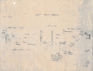
- East Penn Branch_1
- Hits: 3392
-
Description:
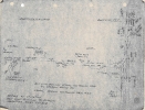
General overview of Belt Line Junction and the Blandon Low Grade from Belt to Temple.
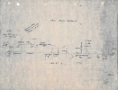
- East Penn Branch_2
- Hits: 3240
-
Description:
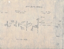
The original East Penn Branch alignment, also known as the "Hill Track," from HILL interlocking to Temple.
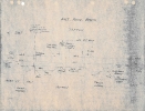
- East Penn Branch_3
- Hits: 3147
-
Description:
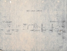
The Hill Track, from Temple to Blandon, continued.
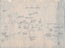
- East Penn Branch_4
- Hits: 3031
-
Description:
Blandon, the convergence of the Hill Track and the Blandon Low Grade.
- East Penn Branch_5
- Hits: 2942
-
Description:
Fleetwood, PA.
- East Penn Branch_6
- Hits: 3008
-
Description:
Lyons and Bowers, between Fleetwood and Topton, PA.
- East Penn Branch_7
- Hits: 3015
-
Description:
Topton, PA. Highest point of elevation on the East Penn Branch (hence the name "Topton") and junction with the 4.4 mile Allentown Branch to Kutztown, PA.

- East Penn Branch_8
- Hits: 3056
-
Description:
Mertztown, between Topton and Alburtis, PA.
- East Penn Branch_9
- Hits: 3163
-
Description:
Alburtis, PA, junction with the Catasauqua and Fogelsville (C&F) Branch.
Today's Image

Did You Know?
Downloads
 A variety of Reading Company operations related documents, etc. that may be of use in your modeling efforts.
A variety of Reading Company operations paperwork, such as train orders, clearance forms, etc. that will help you operate your Reading layout in a prototypical manner.
Public Timetables, Employe Timetables, and Rulebooks that provide much useful operational information.
Signs, billboards, and other FREE goodies for your use. We ask only that you help spread the word about The Reading Modeler!
Downloadable reference documents on the various classes of Reading Company Freight and Passenger rolling stock.